
 Teaser
Beyond 2D Matching: A Unified Single-Stage Framework for Geometry-Aware Cross-View Object Geo-Localization
Teaser
 Method
 Data
Data
 Results
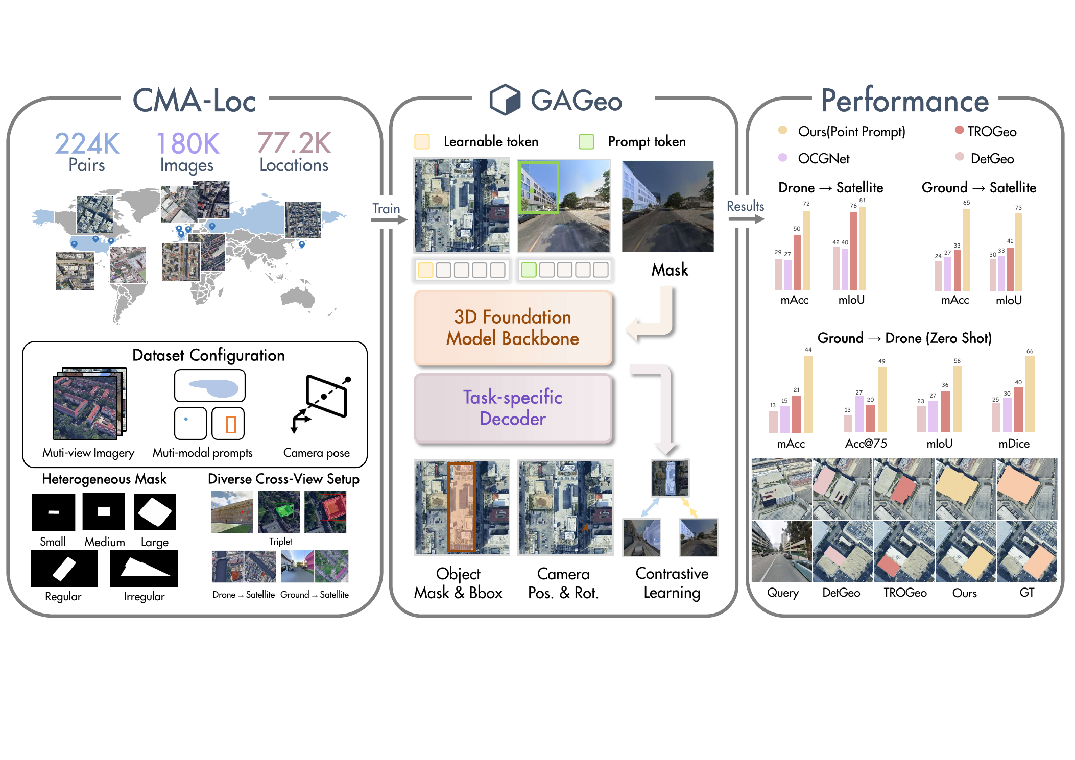
We introduce CMA-Loc and GAGeo for cross-view object geo-localization: locating a prompted target object from a ground or drone query view inside geo-tagged reference imagery. CMA-Loc supplies large-scale multi-prompt supervision with camera poses, while GAGeo adapts a 3D foundation model into a unified single-stage framework for bounding box, segmentation mask, and camera pose prediction.
01
Multi-view inputs
Ground, drone, and satellite views define query-reference localization pairs.
02
Prompt encoding
Point, box, and mask prompts identify the target in the query view.
03
Geometry interaction
Prompt tokens and task tokens interact through a geometry-aware 3D backbone.
04
Multi-task decoding
GAGeo predicts target boxes, masks, camera position, and camera rotation.
Paper overview
CMA-Loc dataset and GAGeo framework
The paper introduces a large-scale building dataset with multi-modal prompts and a geometry-aware model that localizes targets across ground, drone, and satellite views.
The Model
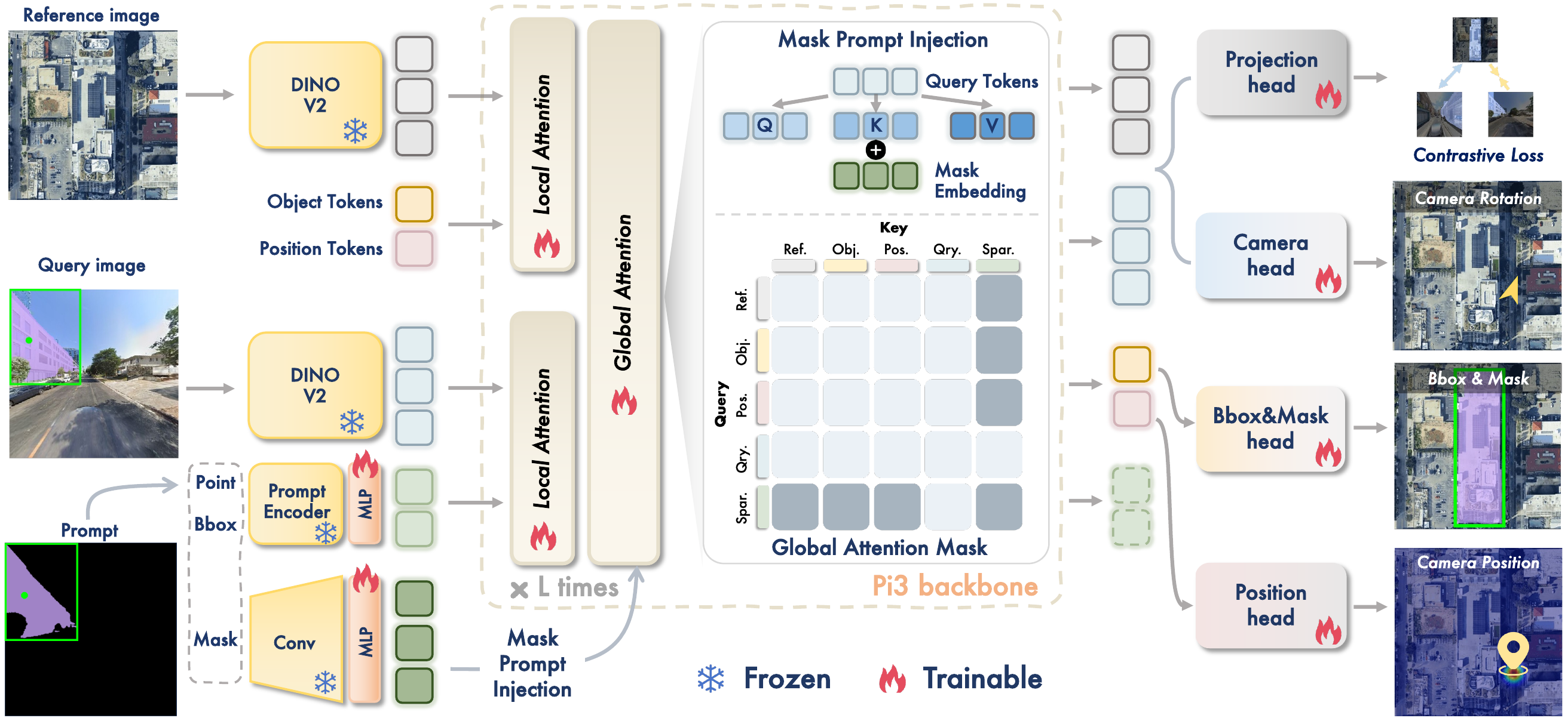
GAGeo shifts CVOGL beyond 2D appearance matching by adapting the geometric prior of \(\pi^3\), a permutation-equivariant 3D foundation model, to cross-view object localization [1]. The framework fuses DINOv2 visual tokens, SAM2-style prompt tokens, and task-specific object and position tokens, then decodes boxes, masks, camera position, and camera rotation in one forward pass.
Geometry-aware architecture
GAGeo single-stage pipeline
Query prompts are encoded on the ground or drone view, task tokens are attached to the reference view, and the geometry-aware backbone predicts localization, segmentation, and pose jointly.
\(I_q, I_r\)
Cross-view inputs
\(\pi^3\)
GAGeo transformer
Query
Reference
Prompt
Task
+
\(T_{\mathrm{geo}}\)
Interaction
\(\hat{y}_r\)
Reference outputs
Satellite Anchor
\(\mathcal{L}_{cl} = -\log p(z_q^+ | z_r)\)
Box / Mask / Pose
\(\hat{b}_r, \hat{m}_r, \hat{p}, \hat{R}\)
The Data
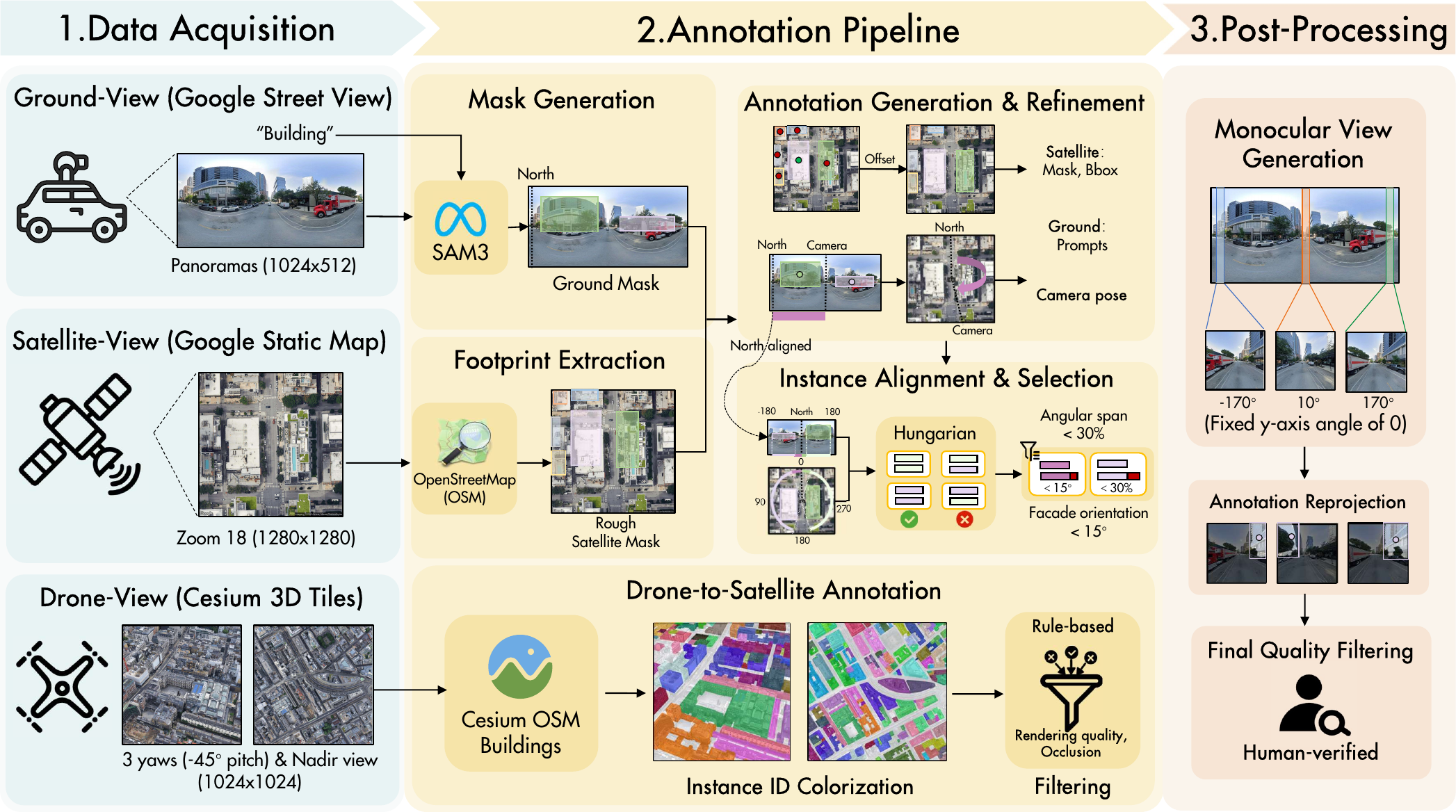
CMA-Loc is a large-scale Cross-view Multi-prompt Annotated Localization dataset for building-focused geo-localization. It contains 112,063 ground-satellite and 111,704 drone-satellite instance pairs across 77,200 locations in 8 global cities, with point, bounding box, and mask prompts plus camera pose metadata.
Dataset coverage
3D view-distribution sketch
Rotate and inspect a compact visual sketch of CMA-Loc's cross-view sources, including ground-satellite pairs, drone-satellite pairs, triplet evaluation samples, and out-of-distribution benchmarks.
City distribution
CMA-Loc pairs by city
Hover over each slice to inspect the pair counts reported in the supplementary city statistics table.
The Results
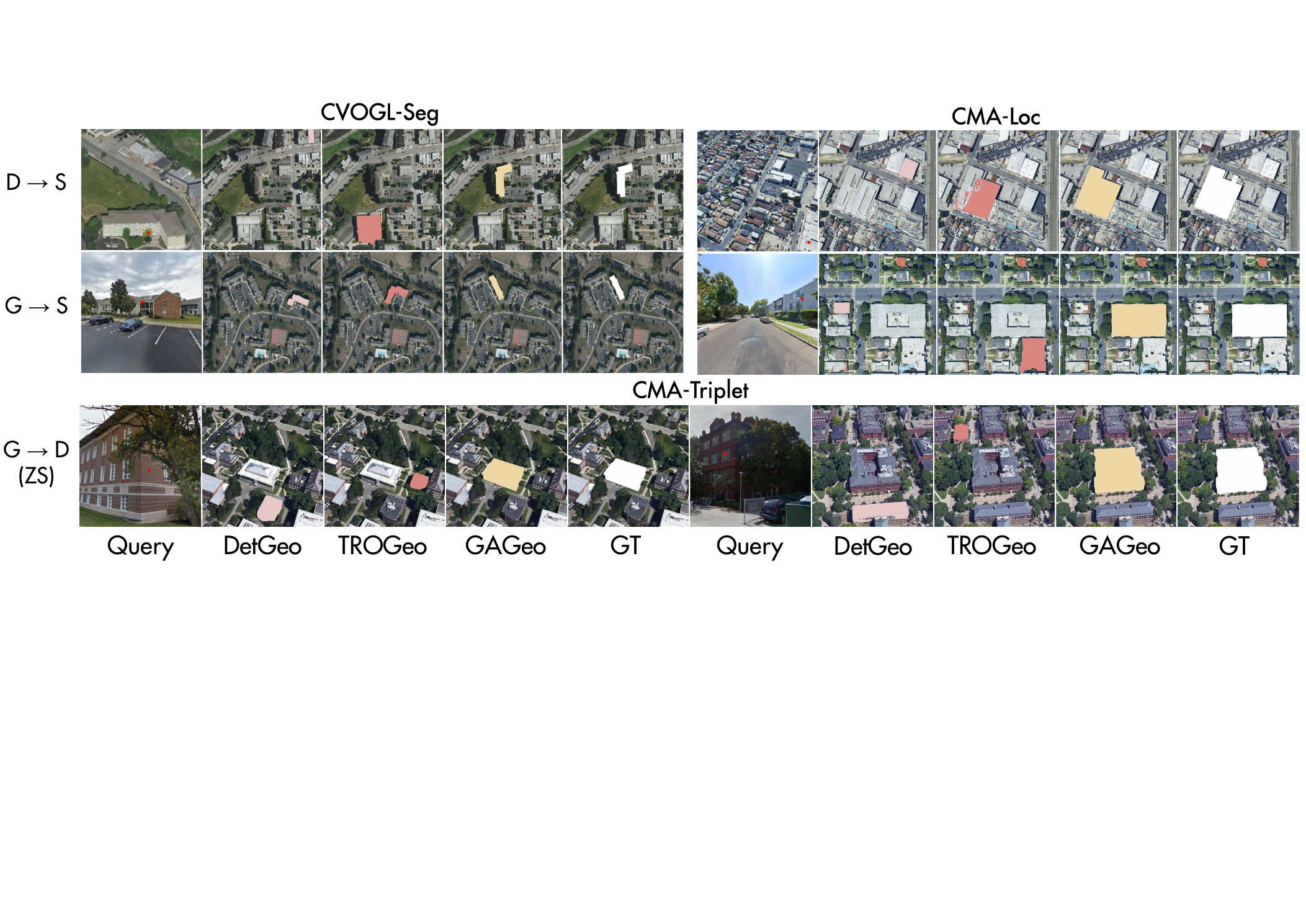
GAGeo sets a new state of the art across detection, segmentation, and zero-shot transfer settings. It improves both drone-to-satellite and ground-to-satellite localization on CMA-Loc, transfers to CVOGL-Seg without task-specific fine-tuning, and reaches strong zero-shot ground-to-drone performance through satellite-anchored contrastive learning.
CMA-Loc benchmarks
Vertical task comparison
Qualitative gallery
Cross-view localization examples
Use the controls to switch between qualitative localization, segmentation comparison, and camera pose visualization.
Qualitative
Cross-view localization results
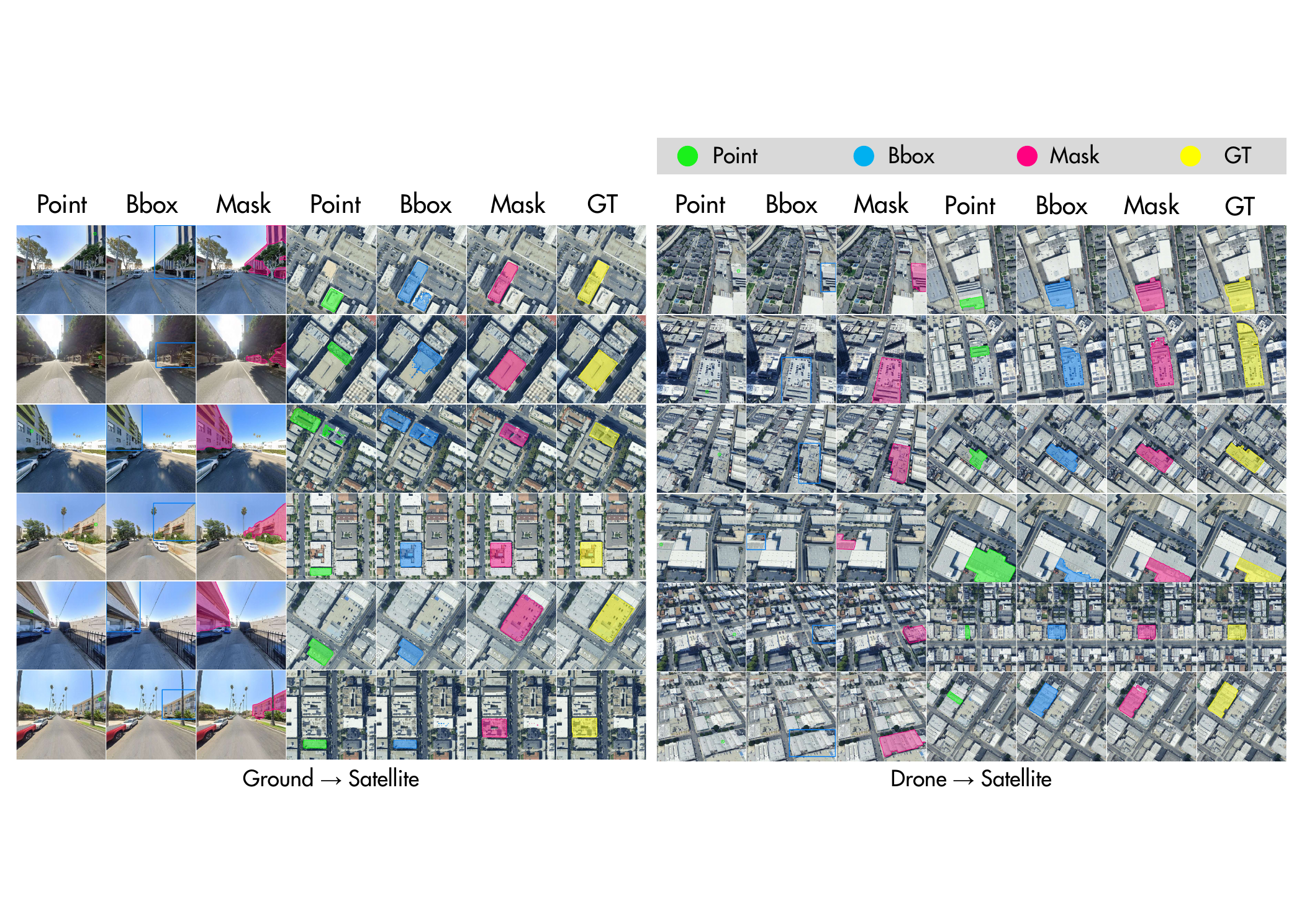
Segmentation
Mask quality comparison
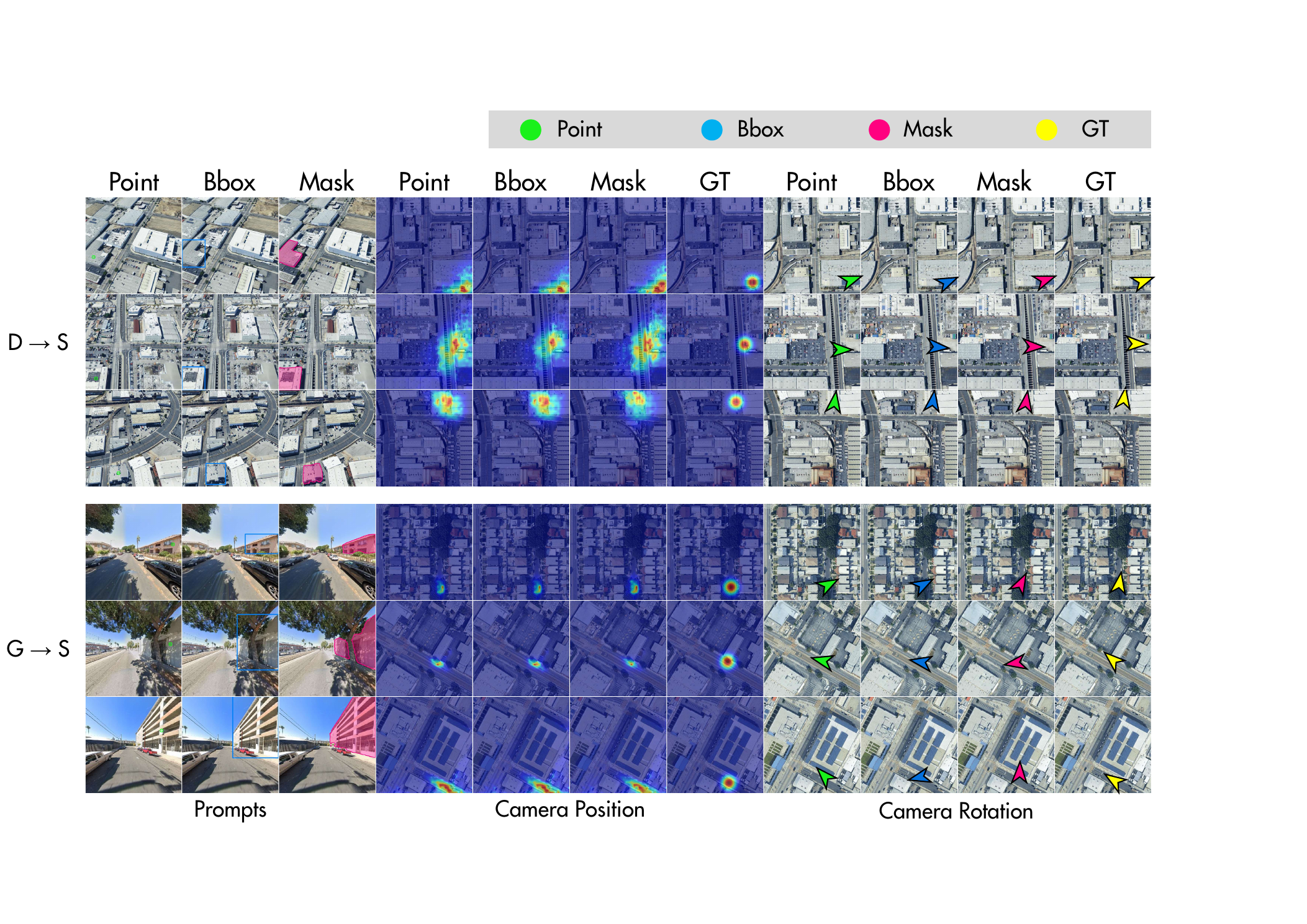
Geometry
Camera pose visualization
Result tables
Quantitative comparison
Hover to scan rows and columns; click a row to pin it while comparing methods across settings.
| CVOGL-Seg Detection | ||||||
|---|---|---|---|---|---|---|
| Method | D->S mAcc | D->S Acc@75 | D->S Acc@50 | G->S mAcc | G->S Acc@75 | G->S Acc@50 |
| Sample4Geo | 0.70 | 0.21 | 2.88 | 0.42 | 0.10 | 1.75 |
| DetGeo | 12.09 | 11.41 | 21.79 | 6.15 | 5.76 | 10.89 |
| OCGNet | 12.75 | 12.13 | 23.84 | 8.77 | 8.74 | 16.14 |
| TROGeo | 7.10 | 2.77 | 21.89 | 3.51 | 1.54 | 9.76 |
| GAGeo | 29.43 | 30.55 | 50.27 | 19.37 | 19.28 | 35.21 |
| CVOGL-Seg Segmentation | ||||||||
|---|---|---|---|---|---|---|---|---|
| Method | D->S mIoU | D->S mDice | D->S AAE | D->S ME | G->S mIoU | G->S mDice | G->S AAE | G->S ME |
| Sample4Geo + SPS | 8.73 | 11.90 | 3554.1 | 112.40 | 5.10 | 7.14 | 3585.1 | 133.47 |
| DetGeo + SPS | 19.14 | 21.71 | 5377.1 | 172.24 | 10.12 | 11.43 | 4809.6 | 208.39 |
| OCGNet + SPS | 20.94 | 23.71 | 6893.0 | 159.25 | 14.09 | 15.76 | 7073.2 | 180.67 |
| TROGeo + SPS | 24.30 | 28.66 | 8823.8 | 137.85 | 10.53 | 12.25 | 8175.8 | 193.37 |
| GAGeo | 46.79 | 53.38 | 2191.3 | 102.38 | 33.02 | 38.36 | 3027.6 | 113.47 |
Zero-shot detection and segmentation performance on the CVOGL-Seg test set.
Higher mAcc, Acc@K, mIoU, and mDice are better.
Lower AAE and ME are better.
Together, CMA-Loc and GAGeo address both sides of the CVOGL bottleneck: richer geometric supervision at dataset scale, and a single-stage model that uses 3D priors to bridge viewpoint gaps instead of relying only on 2D appearance matching.
Citation
Please cite the paper if you use CMA-Loc or GAGeo.
@inproceedings{wang2026beyond2dmatching,
  title={Beyond 2D Matching: A Unified Single-Stage Framework for Geometry-Aware Cross-View Object Geo-Localization},
  author={Wang, Liyao and Wu, Ruipu and Xu, Haojun and Shi, Lei and Huang, Linjiang and Liu, Si},
  booktitle={European Conference on Computer Vision},
  year={2026}
}